
Imagine standing on a Himalayan ridge at sunrise.
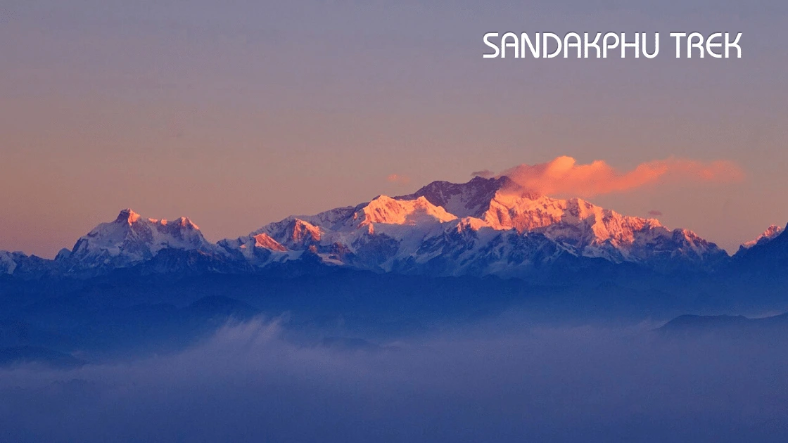
Directly ahead, the enormous massif of Kangchenjunga begins glowing gold.
Its surrounding peaks form a silhouette resembling a person lying peacefully beneath the sky — the legendary Sleeping Buddha.
Turn your eyes farther west.
On a sufficiently clear morning, another group of mountains appears on the horizon.
Makalu. Lhotse. And Mount Everest.
There aren’t many treks where you can stand in one place and see four of the world’s five highest mountains.
Sandakphu is one of them.
Welcome to the first edition of TRAIL ADDICTED — our Travel Addicted series dedicated to India’s greatest trekking trails.
And we’re beginning with one of the most spectacular Himalayan ridge walks in eastern India.
Why Is Sandakphu So Special?
Sandakphu isn’t the highest trek in India.
It isn’t the hardest.
It doesn’t require technical mountaineering.
But what it delivers is extraordinary.
At approximately 3,636 metres, Sandakphu is the highest point in West Bengal and sits along the Singalila Ridge in Darjeeling district, close to the India–Nepal border.
The trail travels through:
Rhododendron forests.
Bamboo groves.
Magnolia and oak forests.
Small Himalayan settlements.
Sections running beside or across the India–Nepal frontier.
Singalila National Park.
And some of the finest high-Himalayan panoramas accessible on a moderate trek.
But Sandakphu has one trump card.
Four of the World’s Five Highest Mountains
On a clear day, Sandakphu provides views towards:
Mount Everest — 8,848.86 m
Kangchenjunga — 8,586 m
Lhotse — 8,516 m
Makalu — 8,485 m
West Bengal Tourism officially highlights the visibility of all four from Sandakphu.
And then there’s the mountain formation that steals the show.
Meet the Sleeping Buddha
The Kangchenjunga massif and neighbouring peaks create one of Sandakphu’s most famous views.
From the Singalila Ridge, their combined silhouette resembles a giant reclining figure.
Hence the name:
Sleeping Buddha.
West Bengal Tourism identifies the formation around Kangchenjunga and peaks including Kumbhakarna and Pandim with the famous Sleeping Buddha view.
Watching the first sunlight strike this enormous wall of mountains is one of the primary reasons trekkers come to Sandakphu.
And unlike a single summit viewpoint, the Singalila trek repeatedly gives you Himalayan panoramas as you walk along the ridge.
This isn’t simply about reaching Sandakphu.
The trail itself is the attraction.
Sandakphu Trek Route at a Glance
There are several possible itineraries depending on where you start, whether you extend to Phalut, and how much time you have.
For a classic trekking experience, I’d recommend allowing approximately 6–7 days including arrival and departure logistics.
A practical route looks like:
Day 1
Bagdogra / NJP → Manebhanjan
Day 2
Manebhanjan → Chitre → Meghma → Tumling
Day 3
Tumling → Gairibas → Kalipokhri
Day 4
Kalipokhri → Sandakphu
Day 5
Sandakphu → Gurdum
Day 6
Gurdum → Srikhola → onward transfer
Day 7
Buffer / Darjeeling / departure
You can also extend the adventure from Sandakphu towards Phalut, which creates a longer and more complete Singalila Ridge trek.
DAY 1 — Bagdogra/NJP to Manebhanjan
Your Sandakphu journey begins long before you start trekking.
The nearest major airport is Bagdogra, while New Jalpaiguri — NJP — is the principal nearby railway gateway.
From Siliguri/NJP/Bagdogra, travel towards Manebhanjan.
West Bengal Tourism places Manebhanjan around 26 km from Darjeeling and identifies it as the traditional starting point and gateway to the Sandakphu trekking route.
Manebhanjan sits at roughly 7,054 ft.
Spend the night here.
Don’t rush to start trekking immediately after a long flight or train journey.
Use the evening to:
Check your equipment.
Meet your guide if you’re trekking with one.
Organise permits/current park formalities.
Buy anything you’ve forgotten.
Hydrate.
And sleep early.
Tomorrow the walking begins.
DAY 2 — Manebhanjan to Tumling
This is where your legs officially meet Sandakphu.
The first important settlement is:
Chitre
Chitre sits roughly 3 km from Manebhanjan at around 8,340 ft.
Don’t let the distance fool you.
West Bengal Tourism describes this initial section as one of the steeper portions of the Sandakphu route.
It’s an immediate reminder:
Mountain kilometres aren’t city kilometres.
The trail climbs through forests containing pine, fir, birch and bamboo.
Eventually you reach the small settlement of Chitre and its monastery.
Take a break.
Drink water.
Then continue.
Lamey Dhura
The route climbs further along the ridge.
Small settlements and tea stops begin appearing.
The landscape gradually opens.
Meghma
At roughly 9,514 ft, Meghma’s name comes appropriately from megh — cloud.
And on the right day, that’s exactly what you’ll be walking through.
The trail around here becomes particularly interesting because you’re travelling close to the international border.
Parts of the traditional route move between India and Nepal before reconnecting farther ahead.
Eventually you’ll reach:
Tumling
Tumling makes an excellent first major overnight stop.
On a clear evening, you’ll start understanding what makes the Singalila Ridge special.
And if tomorrow morning is clear…
your first serious Himalayan show may begin.
Overnight:
Tumling
DAY 3 — Tumling to Kalipokhri
Wake up early.
Really early.
Because your first instinct after seeing the morning sky might be to go back to sleep.
Don’t.
Walk outside.
If the mountains are clear, you’ll start seeing the enormous Himalayan skyline.
After breakfast, continue through the Singalila region.
This section brings you deeper into one of the trek’s other great attractions.
Singalila National Park
Sandakphu and Phalut lie within the Singalila landscape.
West Bengal Tourism describes the national park as approximately 78.6 sq km of rhododendron forest, alpine valleys and rich Himalayan biodiversity.
The park is also habitat for the endangered red panda as well as Himalayan black bear and numerous bird species. Incredible India highlights oak, bamboo, magnolia and rhododendron forests and more than 120 Himalayan and Indo-Burma bird species.
Seeing a red panda would be extraordinarily lucky.
Don’t undertake the trek expecting a wildlife sighting.
Instead, appreciate that you’re walking through its habitat.
Move quietly.
Don’t leave waste.
Don’t disturb wildlife.
And never treat a national park like an outdoor party venue.
Gairibas
From Tumling, the trail eventually descends towards Gairibas.
Enjoy the descent.
Because mountains have a habit of charging interest.
You’ll climb again.
After Gairibas, continue towards Kalipokhri.
Kalipokhri
The settlement is named after its small dark-coloured sacred lake.
This becomes your overnight base before tomorrow’s push to Sandakphu.
By now the altitude is noticeable.
Keep the evening quiet.
Eat well.
Hydrate.
And get some sleep.
Tomorrow is summit day.
Overnight:
Kalipokhri
DAY 4 — Kalipokhri to Sandakphu
This is the day you’ve been waiting for.
Leave Kalipokhri and continue climbing towards Sandakphu.
Some sections are demanding.
Take your time.
You’re now approaching approximately 3,600 metres.
This isn’t a race.
Walk steadily.
Breathe.
Drink water.
Stop when needed.
And eventually…
Welcome to Sandakphu
3,636 metres.
The highest point in West Bengal.
Drop your backpack.
Catch your breath.
And look around.
Because on a clear day, one of the greatest mountain panoramas in India is waiting for you.
Kangchenjunga dominates one side of the horizon.
Farther west sit Everest, Lhotse and Makalu.
Four 8,000-metre giants.
One ridge.
One viewpoint.
That’s Sandakphu.
But Don’t Celebrate Too Early
The greatest show may happen tomorrow morning.
So eat.
Stay warm.
Charge your camera.
Prepare your layers.
And set the alarm before sunrise.
Overnight:
Sandakphu
THE SANDAKPHU SUNRISE
This deserves its own section.
Wake before dawn.
Wear everything warm you brought.
Step outside.
And wait.
Initially the mountains may appear as dark silhouettes.
Then the horizon changes colour.
Blue becomes purple.
Purple becomes orange.
And eventually the first sunlight touches the highest Himalayan summits.
The Kangchenjunga massif begins glowing.
The Sleeping Buddha slowly reveals itself.
Farther west, Everest and its neighbouring giants catch the morning light.
No photograph can guarantee what you’ll experience.
Clouds can block everything.
Weather can change within minutes.
That’s mountain travel.
But when Sandakphu gives you a clear sunrise…
you’ll understand why trekkers keep returning.
DAY 5 — Sandakphu to Gurdum
After sunrise and breakfast, begin descending.
The return journey doesn’t simply retrace the same trail.
A popular descent heads towards Gurdum through forests and quieter landscapes.
After spending several days walking high ridges, descending into thicker forest feels like entering another ecosystem.
Your knees may also remind you that descending isn’t necessarily easier than climbing.
Use trekking poles if they help you.
Take controlled steps.
And don’t rush steep descents.
Overnight:
Gurdum
DAY 6 — Gurdum to Srikhola
Today’s walk continues towards Srikhola.
West Bengal Tourism describes Srikhola as a mountain settlement around 6,900 ft surrounded by magnolia, chestnut, oak, birch, pine and rhododendron forests, with a river adding to the landscape.
After several days of exposed ridges and Himalayan panoramas, Srikhola feels completely different.
Green.
Forested.
Peaceful.
And lower.
From here, onward road connections take you towards Rimbik, Manebhanjan, Darjeeling or Siliguri depending on your itinerary.
Your trek is finished.
Your legs will know it.
OPTIONAL EXTENSION — SANDAKPHU TO PHALUT
If you have additional time and want a more serious trekking experience…
don’t descend immediately from Sandakphu.
Continue towards Phalut.
Phalut sits at approximately 11,811 ft and is another major high point of the Singalila Ridge.
West Bengal Tourism places Phalut about 21 km beyond Sandakphu.
This extension gives you more time on the high ridge and even more expansive Himalayan views.
Phalut is particularly famous for its imposing view of the Kangchenjunga massif.
If you’re travelling primarily for trekking rather than simply reaching Sandakphu, the Sandakphu–Phalut combination deserves serious consideration.
Best Time for the Sandakphu Trek
There are two particularly attractive windows.
Spring — April to May
Want colour?
Come for the rhododendrons.
West Bengal Tourism notes that the route becomes filled with rhododendron blooms during spring, particularly around April and May.
The forest can explode with reds, pinks and other colours.
Spring is about:
Flowers.
Forests.
Birdlife.
And the experience of Singalila itself.
Autumn — October to November
Want mountain views?
This would be my preferred season.
Post-monsoon conditions can offer clearer Himalayan visibility.
West Bengal Tourism specifically identifies late October to mid-December as a strong period for snow-peak views around Phalut.
October and November combine:
Clearer skies.
Crisp mountain air.
Excellent sunrise potential.
And spectacular views of the Himalayan giants.
How Difficult Is the Sandakphu Trek?
I’d classify Sandakphu as a moderate Himalayan trek for a reasonably fit beginner, provided the itinerary allows sensible acclimatisation and the person is prepared for consecutive walking days.
The challenge isn’t technical climbing.
It’s the combination of:
Altitude.
Repeated ascents and descents.
Cold.
Long walking days.
Changing weather.
And several consecutive days on your feet.
You don’t need to be a mountaineer.
But don’t arrive without preparation.
How Should You Train?
Start preparing several weeks before departure.
Focus on:
Brisk walking.
Stair climbing.
Cycling.
Jogging.
Leg strengthening.
Squats.
Lunges.
Core work.
And longer weekend walks.
The best preparation for walking uphill for hours…
is spending time walking uphill.
If you live near hills, use them.
What About Altitude?
Sandakphu reaches approximately 3,636 metres.
That’s high enough for altitude to matter.
Altitude affects different people differently, irrespective of fitness.
Don’t assume being young or athletic makes you immune.
Ascend gradually.
Stay hydrated.
Avoid unnecessary overexertion.
And pay attention to symptoms.
If significant altitude-related symptoms develop, don’t simply keep climbing because you’ve paid for the trip.
Follow your trek leader’s safety protocol and seek appropriate medical assistance.
The mountain will still be there.
What Should You Pack?
Don’t pack your entire wardrobe.
But don’t underestimate mountain weather either.
Your essentials should include:
Good trekking shoes.
Trekking socks.
Base layers.
Warm fleece.
Insulated jacket.
Waterproof/windproof outer layer.
Trekking trousers.
Thermal layers depending on season.
Gloves.
Warm cap.
Sun cap.
Sunglasses.
Sunscreen.
Reusable water bottles.
Headlamp.
Small daypack.
Trekking poles if preferred.
Personal medicines.
Basic toiletries.
Power bank.
Rain protection for backpack.
And your camera.
Because you’re going to use it.
A lot.
Sandakphu by Land Rover — Do You Have to Trek?
Here’s what makes Sandakphu unusual.
You don’t necessarily have to walk all the way.
Manebhanjan is famous for its old Land Rovers, and West Bengal Tourism confirms that Land Rover trips operate from Manebhanjan towards Sandakphu.
The rugged road itself has become part of Sandakphu’s identity.
This opens the destination to travellers who aren’t interested in completing the entire trek.
But don’t confuse the two experiences.
Driving to Sandakphu gives you the destination.
Trekking gives you the journey.
Chitre.
Meghma.
Tumling.
Gairibas.
Forests.
Tea houses.
Clouds.
Border villages.
Long conversations while walking.
The anticipation of seeing Sandakphu getting closer every day.
If you’re physically able and genuinely enjoy trekking…
walk.
Can Beginners Do Sandakphu?
Yes — with preparation.
In fact, Sandakphu can make an excellent introduction to multi-day Himalayan trekking.
But “beginner-friendly” doesn’t mean “zero preparation required.”
You should be comfortable walking for several hours.
Train before travelling.
Use proper footwear.
Don’t carry unnecessary weight.
Choose an itinerary with reasonable progression.
And respect altitude and weather.
The Himalayas don’t care whether Instagram called a trek easy.
Sandakphu vs Other Himalayan Treks
Sandakphu offers something different from many Uttarakhand and Himachal treks.
You’re not coming only for a summit.
You’re walking a ridge.
You’re travelling through a biodiversity-rich national park.
You’re moving beside an international border.
You’re passing tiny settlements.
And you’re looking towards an extraordinary portion of the Himalayan chain.
The landscape changes continuously.
That’s why Sandakphu belongs on the list of treks to do at least once.
Responsible Trekking in Singalila
The mountains don’t need another plastic bottle.
Carry your waste back.
Refill water wherever safe and practical rather than repeatedly purchasing disposable bottles.
Stay on established trails.
Respect local communities.
Don’t disturb wildlife.
Keep noise down inside the national park.
Don’t chase red pandas or other animals for photographs.
Support local homestays, guides and businesses.
And remember:
You are a visitor here.
Travel accordingly.
Sandakphu Trek — Quick Facts
Highest point: Sandakphu
Altitude: Approximately 3,636 m / 11,930 ft
State: West Bengal
Region: Singalila Ridge, Darjeeling district
Nearest airport: Bagdogra
Nearest major railway station: New Jalpaiguri
Traditional trek gateway: Manebhanjan
Difficulty: Moderate
Ideal duration: Around 6–7 days including transfers; longer with Phalut
Best for mountain views: October–November
Best for rhododendrons: April–May
Major attraction: Sleeping Buddha + Everest/Kangchenjunga/Lhotse/Makalu panorama
Optional extension: Phalut
Frequently Asked Questions
Is Sandakphu the highest peak in West Bengal?
Yes. At approximately 3,636 metres, Sandakphu is West Bengal’s highest point.
Can Mount Everest really be seen from Sandakphu?
Yes, when visibility is good. West Bengal Tourism identifies Everest, Kangchenjunga, Lhotse and Makalu among the major peaks visible from Sandakphu.
What is the Sleeping Buddha?
It’s the famous visual formation created by the Kangchenjunga massif and neighbouring peaks when viewed from the Singalila region.
Is Sandakphu suitable for beginners?
A reasonably fit beginner can consider it with appropriate training, equipment, acclimatisation and professional/local guidance.
Which is better: Sandakphu or Sandakphu–Phalut?
Sandakphu alone works well when time is limited. Adding Phalut creates a longer trekking experience with more time on the Singalila Ridge.
Can I reach Sandakphu without trekking?
Yes. Rugged vehicle access, historically associated with Land Rovers from Manebhanjan, provides another way of reaching the area.
Which airport should I use?
Bagdogra is the nearest major airport, while NJP is the nearest major rail gateway.
When can I see rhododendrons?
Spring, particularly April–May, is associated with rhododendron blooms along the Singalila route.
Final Thoughts
Some treks make you work incredibly hard for one great viewpoint at the end.
Sandakphu is different.
The journey itself keeps rewarding you.
A monastery above Chitre.
Clouds drifting through Meghma.
Forests around Tumling.
The wilderness of Singalila.
A cup of hot tea after hours of walking.
And then…
that morning.
You step outside before sunrise.
The sky slowly brightens.
The silhouette of the Sleeping Buddha appears.
Kangchenjunga catches the first light.
Far away stand Everest, Lhotse and Makalu.
Suddenly your tired legs don’t matter.
The cold doesn’t matter.
Yesterday’s climb doesn’t matter.
You’re standing on the highest point of West Bengal…
looking towards four of the highest mountains on Earth.
And perhaps that’s the addiction of trekking.
The harder you walk, the more extraordinary the world becomes.
TRAIL ADDICTED #01
Walk farther. Climb higher. Discover what’s beyond the road.
Mountain conditions, park access, accommodation, permits, guide requirements and local regulations can change. Verify the latest rules with official/local authorities before starting the trek.